Google Maps needs very little introduction as a powerful tool for navigation and exploration that's well used worldwide. But when it comes to education there is more to think about as this can be a very useful teaching tool.
To be clear this isn't Google Earth, which has its own dedicated Earth Education tool. Rather, this is the mapping tool crammed with features that can help students to learn, even if it used primarily for navigation.
From learning about new places such as monuments and historical sites to planning school trips and even virtually visiting worldwide spots -- it's all possible using Google Maps, which can be accessed from nearly any device.
So can Google Maps help you in education?
What is Google Maps?
Google Maps is primarily a mapping tool that shows locations as well as plans journeys using smart routing. Consequently, it can be used to find places and to determine how to get there, including using turn-by-turn navigation.

Google Maps is also a great way to explore virtually as it has all the major historical, scientific, and natural monuments, museums, and sites that the world has to offer.
It is possible to create folders and save locations so a teacher can plan a virtual tour of sites for a lesson, or to set for students to explore in their own time.
Thanks to a wide selection of user content including pictures, videos, and reviews, there is tons of extra information to be found right there within the Maps software. But you can also use it to head off to visit the websites of spots that may be of interest for deeper research.
How does Google Maps work?
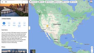
Google Maps is very simple and easy to use. Type in an area of interest and you'll be zoomed to that on the map and given a selection of options including Directions, Save, Nearby Interests, and the ability to Share using a link.

Select the photos and videos section and the map is minimized so you can explore pictures taken in that area, showing it in the real world. The address will be shown as well as details such as contact telephone numbers, website, and operating hours -- making it ideal for planning a visit.
Zoom in or out easily, layer up terrain, satellite, and traffic views to overlay more information on the map. It's also possible to search an area for nearby points of interest such as restaurants, hotels, attractions, transport, parking, cashpoints, and more.
What are the best Google Maps features?
Google Maps usefully includes a review rating for anything you select. This gives you a helpful at-a-glance score, out of five, for that area based on user reviews. You can then select these individual reviews to learn more based on what's been shared. A great way to help students learn to research an area of interest before they may decide to visit.

Students can use the Maps directions feature to plan a trip, be it by car, on foot, by bike, or using public transport. Learning to use this is a valuable life skill in itself for students of all ages.
The ability to save areas of interest in folders is super helpful. Teachers can set tasks for students where they find places to visit, for example, and have them share these with the class at a later stage.
Since Google Maps is optimized to work on many devices, it can easily be used by students on their own smartphones as well as on school laptops and more.
The use of Street View is helpful as it can let students select a street area to see the location before paying a visit, allowing them to assess where they're going -- safely -- before committing to a trip.
How much does Google Maps cost?
Google Maps is totally free to use. That means you don't have to worry about ads or any hidden premium costs as Google makes this for use by all, internationally.
That includes turn-by-turn navigation, also totally free, so that smartphones are totally capable sat navigation devices, which even take into account live information such traffic, road accidents, tolls, or construction zones.
Since lots of data is updated live, by the community of users, all of that information is also freely available to all who use Google Maps.
Google Maps best tips and tricks
Plan a trip
Have students plan a school trip for which you set the location and create a save folder. Get them to plan the route, find a lunch spot, show points of interest for the visit, and more.
Go virtual
Explore the world virtually by using the photos and videos available as well as Street View to travel as a class, as if really there. This works well when shared via the classroom big screen.
Review
Have students leave reviews on places they've been, including words and photos uploaded to show they know how to capture that and also to share a balanced opinion.

